[AI Readability Summary]
This article compares AOI (Area of Interest) polygon data from Gaode Map and Baidu Map in scenic-area scenarios. It focuses on three core dimensions: boundary fidelity, coverage completeness, and the integrity of scenic spot clusters. The goal is to help GIS practitioners choose the right polygon base data for spatial analysis, cultural tourism projects, and planning workflows.
Technical Specification Snapshot
| Parameter | Details |
|---|---|
| Data Topic | Online map AOI (Area of Interest) polygon data |
| Platforms Compared | Gaode Map, Baidu Map |
| Study Scenarios | Scenic areas / forest parks / national scenic areas |
| Core Dimensions | Spatial coverage, boundary fidelity, completeness of scenic spot composition |
| Language | Chinese |
| License | Originally declared as CC 4.0 BY-SA |
| Star Count | Not applicable (not an open-source repository article) |
| Core Dependencies | GIS spatial analysis, online map APIs, planning map references |
AOI is a foundational polygon dataset in GIS workflows
AOI stands for Area of Interest. It represents real geographic entities with closed boundaries, such as scenic areas, parks, business districts, campuses, and administrative zones. Unlike POI data, which only provides point coordinates, AOI is better suited for carrying information about area, boundaries, category ownership, and spatial structure.
In GIS projects, the value of AOI goes far beyond simply drawing a polygon. It provides a unified spatial foundation for buffer analysis, coverage assessment, resource allocation, geofencing, and thematic mapping. In cultural tourism, ecology, and urban governance projects, this type of data often directly affects analytical conclusions.
 AI Visual Insight: This image shows how AOIs are represented as polygons in a map interface. The key point is that an area of interest is not a single point marker, but a spatial object with a closed boundary, polygon geometry, and explicit areal extent, making it suitable for overlay analysis and geographic statistics.
The distinction between AOI and POI is straightforward
POI: answers "Where is the target?"
AOI: answers "What area does the target cover?"
This comparison makes the difference clear: POI is better for retrieval, while AOI is better for analysis.
The two major online map platforms use clearly different AOI construction strategies
Gaode Map usually places more emphasis on full-area collection, terrain conformity, and fine-grained classification. In natural spaces such as mountains, parks, and forests, its boundaries often align more closely with real landforms. Baidu Map, by contrast, appears to focus more deeply on urban core areas and performs better in mature scenic areas, supporting facilities, and cluster-level coordination.
Both platforms can be used in development through official APIs or data parsing approaches, but AOI is often an advanced capability. In real integrations, you need to pay attention to API application requirements, quota limits, coordinate system differences, and data usage constraints.
 AI Visual Insight: This image shows AOI-related interfaces or result formats in online map platforms. It highlights that developers can access boundary geometries, attribute information, and visualization outputs, while also implying that AOI acquisition is usually more complex than standard POI search and often requires authorization and advanced API access.
AOI use cases are highly concentrated in a few practical domains
scenes = [
    "Spatial distribution analysis",  # Used to assess whether resource allocation is balanced
    "Public service planning",  # Used to site parking lots, restrooms, and rescue stations
    "Tourism carrying capacity assessment",  # Used to analyze scenic area extent and influence range
    "Smart city geofencing"   # Used for visitor flow monitoring and regional operations
]
print(scenes)
This code snippet summarizes the mainstream uses of AOI in spatial governance and real-world business implementation.
Selecting two scenic-area samples from Changsha effectively amplifies platform differences
The samples in this article include Xiangbiwo Provincial Forest Park and the Yuelu Mountain National Key Scenic Area. The former is a suburban natural scenic area with elongated boundaries, complex terrain, and relatively low development intensity. The latter is a mature scenic area in the urban core, with dense attractions and a composite cluster structure.
This sample set is representative: one case tests how well a platform fits natural boundaries, while the other tests how well a platform expresses the overall structure of a complex scenic area.
Xiangbiwo Forest Park is better suited for evaluating boundary fidelity
Xiangbiwo Provincial Forest Park has a planned area of about 344.82 hectares. It has high forest coverage, extends along mountainous terrain, and has an irregular boundary. Targets like this are ideal for exposing whether a platform relies on roads, understands terrain, and applies fine-grained corrections when drawing AOIs.
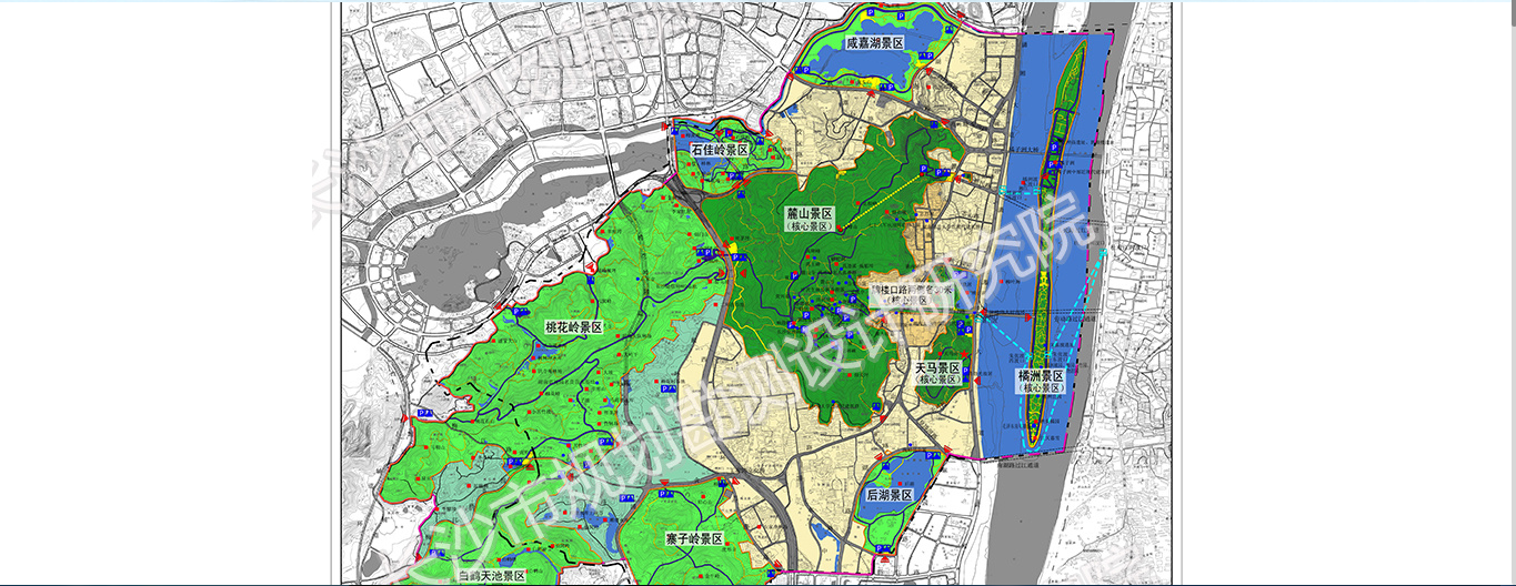
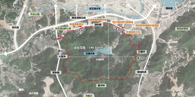 AI Visual Insight: This is a planning map of the forest park. It shows the overall land-use extent, mountain alignment, and functional zoning structure, and can serve as a reference ground truth for AOI comparison. The boundary is elongated and follows the ridgeline, indicating that this type of scenic area cannot be accurately approximated with a simple road envelope.
Coverage comparison shows that Gaode aligns more closely with natural scenic contours
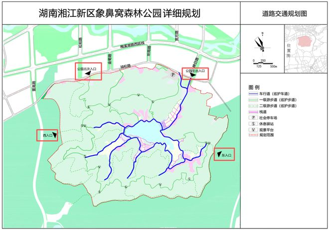 AI Visual Insight: This image provides the planning reference base map for overlay comparison with online map AOI boundaries. Its technical significance lies in offering a relatively authoritative boundary reference for identifying outward expansion, gaps, jagged edges, or road-dependent boundary behavior.
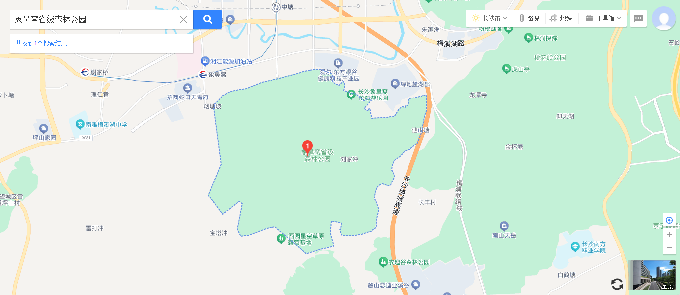
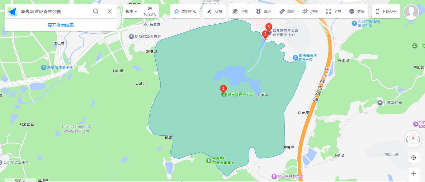 AI Visual Insight: In Gaode Map, the AOI boundary generally follows the mountain trend and closes well. The northeastern section is closer to the planning reference, indicating strong contour-fitting capability in natural scenic-area scenarios. However, the southern and western sections still show some road-dependent artifacts.
 AI Visual Insight: In Baidu Map, the AOI extends beyond the reference boundary, especially at the northeast corner, where additional boundary area appears. This suggests a stronger dependence on roads or layer envelopes. In complex natural terrain, such behavior can lead to over-coverage if the data is not validated against real-world references.
def compare_boundary(platform):
    if platform == "高德":
        return "Better alignment with natural terrain, but with localized road-related offsets"  # Core assessment
    if platform == "百度":
        return "Larger coverage, coarser blocks, and localized outward expansion"  # Core assessment
    return "No result"
This code abstracts the main conclusion from the Xiangbiwo sample into reusable decision logic.
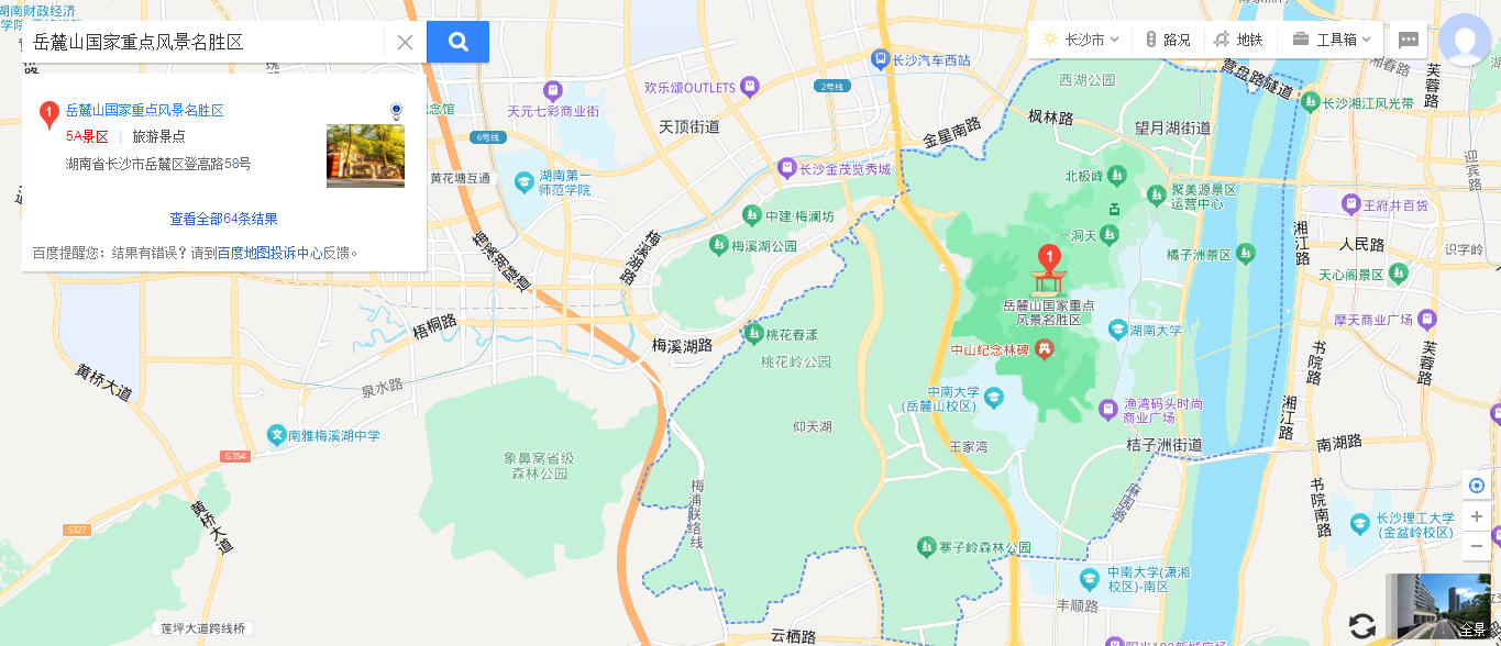
The Yuelu Mountain sample is better suited for validating scenic cluster completeness
The Yuelu Mountain Scenic Area is not a single mountain attraction. It is a composite scenic area that includes multiple clusters, such as Lushan, Orange Isle, Taohualing, and Zhaiziling. For this type of target, the key question is no longer just how precise the boundary is, but whether the platform models the scenic area from a whole-region perspective.
 AI Visual Insight: This image shows the landscape form and core mountain structure of the Yuelu Mountain Scenic Area. It reflects its geographic identity as an urban mountain scenic area and provides intuitive context for understanding its main scenic extent and natural framework.
 AI Visual Insight: This image presents encyclopedic definitions or scope descriptions. Its technical value lies in supplementing the official or public semantic extent of the scenic area, which helps verify whether an AOI covers only the main attraction or the broader combined scenic-area concept.
 AI Visual Insight: This master planning map reveals the multi-cluster structure of the Yuelu Mountain Scenic Area and serves as a key reference for judging AOI completeness. It emphasizes that the scenic area is not an isolated attraction, but a composite spatial unit composed of multiple interrelated subregions.
Cluster completeness comparison shows that Baidu is better suited for macro-level analysis
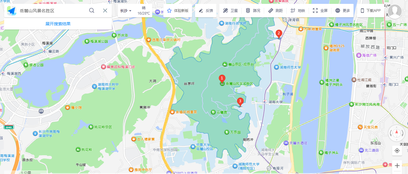 AI Visual Insight: In Gaode Map, the AOI mainly covers the core Yuelu Mountain area, but does not provide a unified representation of associated areas such as Taohualing and Orange Isle. This indicates a stronger bias toward detailed modeling of a single scenic entity rather than coordinated modeling of the full scenic area.
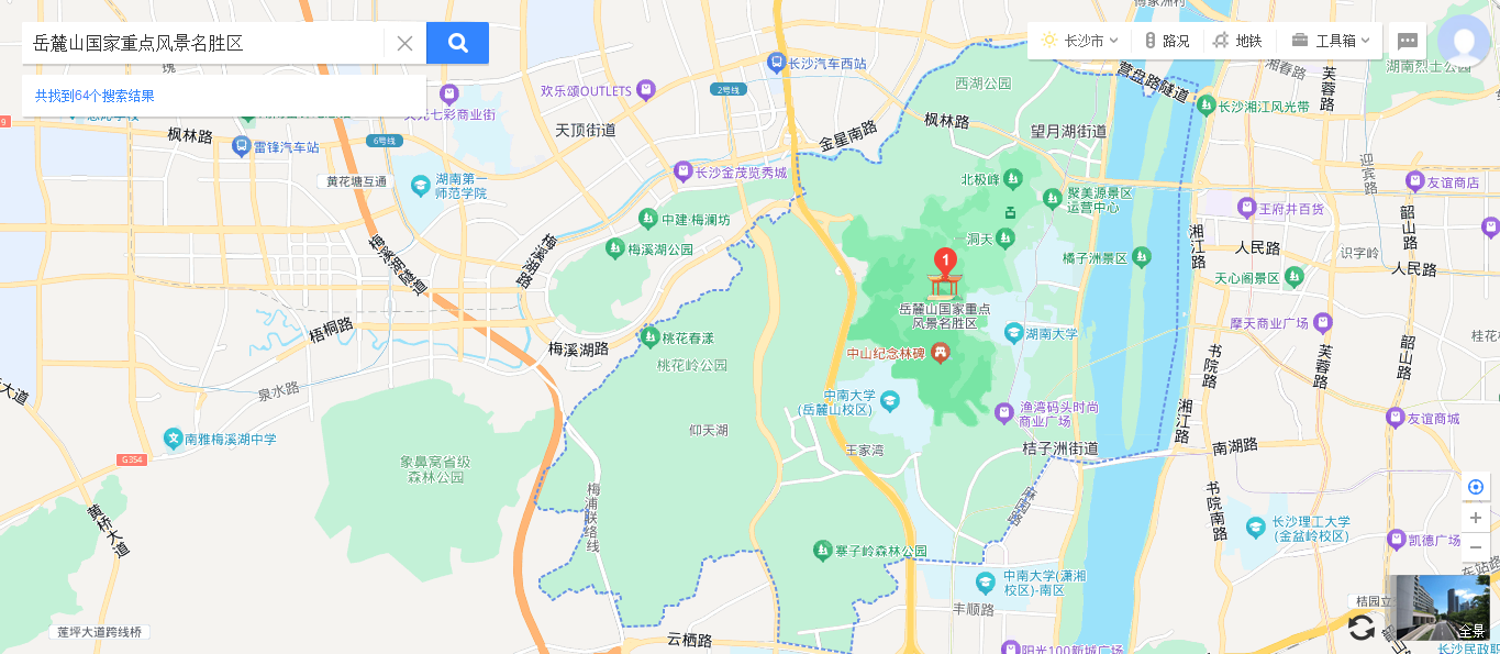 AI Visual Insight: In Baidu Map, the AOI is closer to the overall planning definition and can incorporate multiple core scenic clusters into a single spatial object. This makes it suitable for macro-level area statistics, cross-scenic linkage analysis, and region-wide resource planning, although the granularity of sub-scenic segmentation is relatively limited.
Conclusions should be based on scenario fit rather than absolute superiority
If your target is boundary analysis for suburban forests, parks, mountainous scenic areas, or other natural landscapes, Gaode AOI has a stronger advantage in restoring the extent of individual areas. If your target is a composite scenic area, a mature urban attraction, or cluster-level spatial governance, Baidu AOI is more usable at the overall coordination level.
The more practical strategy is not to choose one platform exclusively, but to cross-validate with both: use Gaode to refine natural boundary details, use Baidu to capture the coordinated scenic-area extent, and then confirm the result with planning maps, remote sensing imagery, or official base maps.
A simple data source selection strategy looks like this
def select_aoi_source(scene_type):
    if scene_type in ["森林公园", "山地景区", "自然保护地"]:
        return "Prioritize Gaode and emphasize boundary fidelity"  # Best for complex natural contours
    if scene_type in ["城市景区", "复合风景区", "景区组团分析"]:
        return "Prioritize Baidu and emphasize overall coordination"  # Best for macro-scale regional analysis
    return "Cross-validate with both platforms"  # Default strategy
This code translates the article’s conclusions into a practical data source selection rule.
FAQ
1. What is the selection standard between AOI and POI in GIS development?
POI is suitable for search, positioning, and point display. AOI is suitable for area statistics, geofencing analysis, coverage assessment, and spatial planning. If your business logic cares about extent rather than just location, you should prioritize AOI.
2. Why is it harder to draw accurate AOIs for natural scenic areas?
Because the boundaries of these scenic areas often follow ridgelines, forest land, and ecological protection lines rather than roads, walls, or administrative borders. If a platform mainly references road networks or low-precision base maps, outward expansion or missing segments can easily occur.
3. Should real-world projects use only one platform?
Usually no. The best practice is to start with a primary platform, cross-check with the other platform, and then overlay planning maps, satellite imagery, or manual verification to improve the interpretability and reliability of AOI data.
Core Summary: Based on two representative scenic-area samples from Changsha, this article provides a structured comparison of AOI data from Gaode Map and Baidu Map. It focuses on boundary fidelity, coverage completeness, and scenic cluster coordination to support base-data selection in GIS development, tourism analytics, and spatial planning.